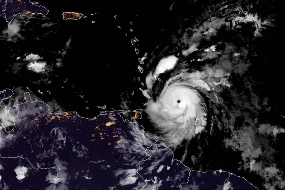
Hurricane Beryl has intensified into a potentially catastrophic Category 5 storm, bringing life-threatening winds and dangerous storm surge to the southeastern Caribbean. The hurricane, which made landfall on Grenada’s Carriacou Island as a Category 4 storm on Monday morning, strengthened to Category 5 status late Monday night with sustained winds of 160 mph.

The National Hurricane Center (NHC) reported at 2 a.m. ET that the storm was “still intensifying,” raising concerns about its potential impact as it moves westward through the Caribbean. Beryl is the first Category 4 hurricane on record to form in June and the earliest Category 5 storm in the Atlantic hurricane season, surpassing previous records.

Key developments:
1. Landfall and Intensification: Beryl made landfall on Carriacou Island at 11:10 a.m. Monday as a Category 4 storm with 150 mph winds. By 11 p.m., it had strengthened to Category 5 with 160 mph winds.
2. Path and Forecast: The hurricane is moving west-northwest at 22 mph and was about 840 miles east-southeast of Kingston, Jamaica, as of 11 p.m. Monday. It is expected to remain a major hurricane as it approaches Jamaica on Wednesday.
3. Impacts on Caribbean Islands: One fatality has been reported in St. Vincent and the Grenadines, with hundreds of homes severely damaged or destroyed. Grenada has reported widespread damage and communication issues. Barbados experienced power outages and flooding.
4. Warnings and Preparations: Jamaica has upgraded its advisory to a hurricane warning, with Prime Minister Andrew Holness urging citizens to take the threat seriously and seek safer ground. A hurricane watch has been issued for the Cayman Islands.
5. Rainfall and Storm Surge: The NHC predicts rainfall of 4 to 8 inches, with up to 12 inches in some areas, potentially causing flash flooding. Storm surges could raise water levels by 3 to 5 feet.
6. Climate Change Connection: Experts note that Beryl’s rapid intensification from a tropical depression to a Category 4 hurricane in just 48 hours may be linked to warmer waters caused by climate change.
7. Future Trajectory: Beryl is expected to remain in the Caribbean Sea for the rest of the week before potentially making landfall on the Yucatán Peninsula as a Category 2 storm, then weakening as it moves into the southwestern Gulf of Mexico.

The unprecedented strength and early formation of Hurricane Beryl have raised concerns among meteorologists and climate scientists. NHC Director Michael Brennan noted that while atmospheric conditions may become less favorable for Beryl to maintain its extreme intensity later in the week, it is expected to remain a major hurricane through at least Wednesday morning.
As Caribbean nations grapple with the aftermath of Beryl’s passage, attention is now focused on Jamaica, which faces the greatest threat from hurricane conditions. Emergency services are preparing for potential widespread damage, and residents are being urged to complete preparations quickly as tropical storm-force winds are expected to reach the island by early Wednesday.
This extraordinary weather event underscores the increasing unpredictability and intensity of Atlantic hurricanes, potentially influenced by climate change. As Beryl continues its path through the Caribbean, authorities and residents alike remain on high alert, bracing for what could be one of the most impactful storms in recent Caribbean history.


