

Meteorologists warn that a second substantial winter storm could strike the Gulf Coast and Eastern Seaboard this weekend, threatening regions still recovering from a devastating system that claimed at least 13 lives and left more than 800,000 customers without electricity across the southern and eastern United States.

The National Weather Service Weather Prediction Center cautioned Monday that increasing potential exists for another significant winter weather event that could deliver heavy snow to the eastern United States beginning Friday, though forecasters emphasized substantial uncertainty remains regarding the system’s ultimate track, intensity and precipitation type. Officials urged residents to monitor evolving forecasts throughout the week as atmospheric conditions crystallize.
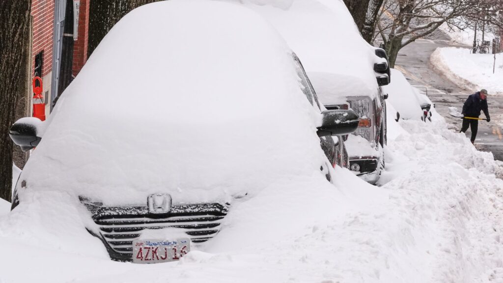
The developing storm emerges as communities struggle to recover from a colossal winter event that deposited more than a foot of snow across a 1,300-mile corridor stretching from Arkansas to New England, PBS documented. The most severely affected locations received up to two feet of accumulation, paralyzing transportation networks and triggering widespread school closures Monday. Deep snow halted traffic, grounded flights and overwhelmed municipal snow removal operations already strained by sustained subfreezing temperatures.
AccuWeather Long Range Expert Paul Pastelok explained that late this week a storm system is anticipated to intensify along a stalled frontal boundary near the Gulf Coast, creating conditions favorable for rain and wintry precipitation across the Southeast. The atmospheric setup bears concerning similarities to the recently departed system, though crucial differences in timing and storm evolution could produce dramatically different outcomes ranging from minimal coastal rain to a potentially destructive nor’easter.
Precipitation could commence as early as Friday along the Gulf Coast, with rain most probable south of Interstate 10 from Louisiana to Florida. The critical variable involves exactly when the system strengthens, which will determine whether snow mixes with rain from Interstate 10 northward across portions of Louisiana, Mississippi, Alabama and Georgia. While these areas already endured snow or ice from the previous storm, preliminary indications suggest the most intense precipitation would largely bypass regions experiencing widespread power outages farther north.
As the storm progresses eastward late Friday through Saturday, precipitation is forecast to migrate northward as well, bringing rain to Florida and potentially wintry weather to the Carolinas. Pastelok emphasized that the rate at which the storm intensifies will prove decisive in determining its final trajectory and whether it advances up the Eastern Seaboard.
Two distinct scenarios exist based on storm development speed. If the system remains weaker or strengthens more gradually, it will likely ride along the Gulf coast and move farther over the Atlantic before turning northward. Under this scenario, snow would concentrate in the Carolinas and New England, with widespread heavy accumulation less probable. The possibility exists that the storm could pivot northward too late, leaving the entire Northeast dry.
Conversely, a rapidly intensifying storm presents higher probability of turning northward sooner, substantially elevating snow risk across the entire Eastern Seaboard. The quickly strengthening system could transform into a nor’easter and generate widespread heavy snow from the mid-Atlantic to New England, accompanied by stronger winds than the previous storm, particularly along coastal areas. A storm that strengthens exceptionally rapidly could track sufficiently westward to deliver snow as far inland as the Appalachians from North Carolina to Pennsylvania.
FOX Weather meteorologists identified two atmospheric patterns that heighten concern about this developing system. The first involves what forecasters characterize as an atmospheric traffic jam over Greenland that can force storms into paths that meander along the coast, creating multi-day weather hazards. The second element consists of an impressive ridge in the Intermountain West that, while producing above-average temperatures in that region, provides a clear pathway for the jet stream to transport systems out of Canada, across the Plains, and exiting somewhere along the Atlantic seaboard. This pattern also ensures continued arctic air funneling into the eastern half of the nation.
Computer forecast models exhibited considerable disagreement Monday regarding the system’s likely evolution. FOX Weather Meteorologists Bob Van Dillen and Jane Minar noted that both the traditional European model and the AI-driven European forecast model indicated greater impacts for the Mid-Atlantic coast, while the American GFS forecast model projected less significant consequences. With several days of data collection remaining, substantial uncertainty persists among various modeling systems regarding this system’s ultimate behavior.
By Thursday, forecasters anticipate a high-altitude disturbance will plunge out of Canada and deepen across the eastern United States by Saturday, generating a robust surface low-pressure system that will interact with the entrenched cold air mass. The collision between these atmospheric elements will produce heavy precipitation, though whether it falls as rain, snow or mixed precipitation depends entirely on factors that remain undetermined as of Monday afternoon.
The placement, strength and timing of the disturbance descending from Canada constitute unknown variables that will govern the storm’s character. Similarly, the timing, track and intensity of the surface low pressure system will dictate whether communities experience rain, snow or mixed precipitation, along with determining how much precipitation occurs over the eastern United States before the storm moves offshore. Impacts to travel and infrastructure from potential snow and wind remain too uncertain for reliable assessment.
The previous storm’s catastrophic toll continues mounting as authorities compile comprehensive damage assessments. At least 13 weather-related fatalities have been confirmed across multiple states, with circumstances varying from hypothermia to traffic accidents to incidents involving snow removal equipment.
New York City Mayor Zohran Mamdani disclosed that at least five individuals who perished were discovered outdoors as temperatures plummeted Saturday, though investigators have not yet determined definitive causes of death. Louisiana’s state health department confirmed two men from Caddo Parish died from hypothermia attributable to the storm.
In Massachusetts, police documented that a snowplow operator backed into a couple walking in a Massachusetts Bay Transportation Authority parking lot in Norwood on Sunday. A 51-year-old woman was killed and her 47-year-old husband hospitalized with injuries. The tragedy underscores how snow removal operations themselves can generate fatal hazards even as they work to restore safe conditions.
Two teenagers lost their lives in separate sledding accidents—a 17-year-old boy in Arkansas and a 16-year-old girl in Texas, authorities confirmed. Tennessee officials announced three additional weather-related deaths, though specific details remained unavailable Monday. The youth fatalities highlight how recreational activities during winter storms, while seemingly innocuous, carry genuine mortality risks particularly on terrain made hazardous by ice and uncontrolled descent speeds.
Power infrastructure suffered extensive damage during the weekend assault. More than 800,000 customers remained without electricity Monday morning, with the majority concentrated in southern states that received substantial sleet and freezing rain, data from poweroutage.com showed. The region’s unfamiliarity with severe winter weather and infrastructure not designed for ice loading on power lines contributed to widespread failures that left communities vulnerable to dangerous cold without heating systems.
Mississippi Governor Tate Reeves characterized the event as the state’s worst ice storm since 1994, noting it prompted the largest-ever deployment of ice-melting chemicals—200,000 gallons—plus salt and sand to treat treacherous roadways. Despite precipitation ending, Reeves warned during a Sunday news conference that danger persists. “That doesn’t mean the danger is behind us,” he emphasized, urging residents to avoid driving unless absolutely necessary and to check on friends and family members who might require assistance.
Freezing rain that created glass-like road surfaces and brought trees and branches crashing onto roads and power lines represented the primary peril across southern states over the weekend. In Corinth, Mississippi, heavy machinery manufacturer Caterpillar instructed employees at its remanufacturing facility to remain home Monday and Tuesday as conditions remained too hazardous for safe commuting.
Transportation networks experienced comprehensive disruption. More than 4,400 flights suffered delays or cancellations nationwide Monday, according to flight tracking website FlightAware.com. Sunday witnessed even more severe aviation impacts, with approximately 12,000 flights canceled and nearly 20,000 delayed. The cascading effects of these cancellations stranded tens of thousands of travelers throughout the nation’s airport system, creating accommodation and rebooking challenges that persisted for days.
At peak intensity Sunday morning, roughly 213 million people lived under some form of winter weather warning, authorities disclosed. The staggering geographic scope of the storm—affecting areas from Montana to the Florida Panhandle—created simultaneous emergencies across multiple time zones that strained emergency management resources and complicated coordination among federal, state and local agencies.
Bitter cold followed in the storm’s wake, establishing conditions that will persist through the upcoming weekend and potentially beyond. Parts of Minnesota recorded temperatures plunging to minus 40 degrees Fahrenheit on Sunday. Numerous communities across the Midwest, South and Northeast awakened Monday to subzero readings. The entire Lower 48 states were forecast to experience their coldest average low temperature of minus 9.8 degrees Fahrenheit since January 2014, former National Oceanic and Atmospheric Administration chief scientist Ryan Maue calculated based on National Weather Service data.
Only record warmth in Florida prevented that national average from dropping even colder, Maue noted. From Montana to the Florida Panhandle, the weather service posted cold weather advisories and extreme cold warnings as temperatures in many locations dipped to zero or below. Wind chill factors made conditions substantially more dangerous, while overnight cold refroze roadways early Monday in what communities experienced as a cruel reprise of the weekend’s treacherous travel conditions.
Frigid temperatures will continue blanketing the eastern half of the United States into next week, forecasters warned. Locations in the Ohio Valley, Northeast and Midwest are projected to remain below freezing throughout the entire week. Even in Texas, the Mississippi River Valley and the Southeast, temperatures are expected to dip below freezing nightly, creating sustained hardship for populations unaccustomed to prolonged arctic conditions.
A reinforced wave of cold air will likely follow the weekend storm system, keeping temperatures locked well below historical averages for at least the first few days of February. Pastelok cautioned that subfreezing temperatures may plunge as far south as central Florida, generating potential for damaging freezes affecting citrus crops in the region. Such agricultural impacts could produce economic consequences extending well beyond immediate weather event costs, particularly if developing fruit suffers freeze damage that reduces yields or quality.
The combination of extreme cold preceding the storm, moisture from the developing system, and arctic air mass persistence creates atmospheric conditions conducive to significant winter weather impacts regardless of the storm’s precise track. Even if the system follows a trajectory that minimizes snowfall in major population centers, the prolonged cold ensures that any precipitation that does fall will create hazardous conditions that linger for extended periods.
In Falmouth, Massachusetts, located approximately an hour’s drive south of Boston, snow fell in sheets Sunday and effectively closed the town. Resident Nell Fields described having to shovel just to let her dog outside after seven inches of accumulation. “I feel that the universe just put a big, huge pause on us with all the snow,” Fields reflected, articulating the disruptive impact winter storms impose on daily routines and normal activities.
On Manhattan’s Upper East Side, January Cotrel expressed enthusiasm for fresh snow on a block that traditionally closes during snowstorms to allow residents to sled, engage in snowball fights and build snowmen. “I pray for two feet every time we get a snowstorm. I want as much as we can get,” she stated. “Let the city just shut down for a day and it’s beautiful, and then we can get back to life.” The contrasting perspectives illustrate how winter storms generate vastly different responses depending on individual circumstances, with some viewing heavy snow as inconvenience and others as welcome respite from urban routines.
The prospect of a second major storm arriving before communities fully recover from the first creates compounding challenges. Snow removal equipment already operating continuously for days will require maintenance. Salt and chemical supplies depleted during the initial response may prove inadequate if the second storm materializes with significant intensity. Power restoration crews working to reconnect hundreds of thousands of customers could face renewed outages if the forecasted system delivers the stronger winds that meteorologists identify as possible under certain development scenarios.
Emergency management officials face the difficult task of maintaining public vigilance for a storm whose characteristics remain uncertain while avoiding alarm fatigue that could cause residents to dismiss warnings if the system ultimately produces minimal impacts. The communication challenge becomes particularly acute when forecast models disagree substantially about likely outcomes, as clear messaging requires confidence that current data cannot yet provide.
The National Weather Service’s emphasis on encouraging the public to monitor forecasts throughout the week reflects this uncertainty while establishing appropriate situational awareness. As atmospheric patterns evolve and computer models ingest additional observational data, forecast confidence will improve, allowing meteorologists to provide increasingly specific guidance about timing, precipitation types and accumulation amounts.
PBS/Fox29/Dailymail


